Thus far, the 2024 hurricane season has been filled with predictions and calm periods juxtaposed against sudden bursts of activity. Currently, the NHC is tracking two tropical waves in the Atlantic Ocean—one of them in the Gulf of Mexico—that may develop into Tropical Storm Francine. Here below is a rundown of the current situation, the forecast, and what to expect in the coming days:
Two Tropical Waves and Their Potential
The NHC continues to monitor two primary systems that have the potential to become tropical storms:
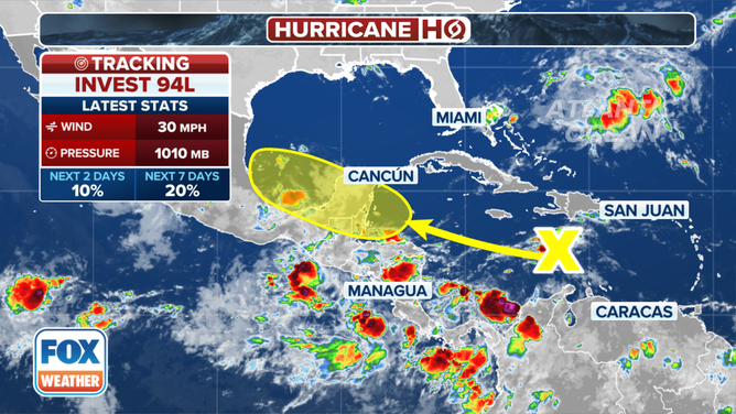
The NHC is currently monitoring a tropical wave in the Gulf of Mexico. This wave is currently located over the Bay of Campeche, west of the Yucatán Peninsula, and is bringing showers and thunderstorms across Guatemala, southeastern Mexico, and the southwestern Gulf of Mexico. Meteorologists’ estimate for the wave currently churning in the Caribbean was a 90% chance of it becoming a tropical storm sometime over the next week, moving north-northwest at a slow pace. If conditions improve—that is, if wind shear decreases and the water warms up—this system could get stronger and eventually affect the U.S. Gulf Coast, particularly Texas and Louisiana.
Tropical Wave: This wave continues to produce showers and thunderstorms over the eastern and central Atlantic. Forecasters say it has a 50-70% chance of development over the next several days as it moves west-northwest. We are closely monitoring its track, but for now, it poses no threat to any land areas.
Gulf System
Meteorologists are most concerned about the tropical wave in the Gulf of Mexico, which has a high possibility of becoming a tropical storm, perhaps a hurricane, over the next 48 hours. We would name the system Francine if it were to strengthen.
Where is it headed?

We expect the system to make landfall as a Category 1 hurricane, potentially as early as Wednesday, near the state line between Texas and Louisiana. It currently brings 50-mph winds as it works its way to becoming a tropical storm by at least Monday, bringing threats of dangerous storm surges, heavy rain, and isolated tornadoes.
What can be expected in affected areas?
Texas and Louisiana: Those on Texas and Louisiana’s coasts should begin to prepare for high winds, heavy rain, and possible flooding. The weather service has warned of a life-threatening storm surge along the coast, with as much as a foot of rain forecast for some areas by Thursday.
New Orleans: The city could see 4-6 inches of rain through the period, with the highest chance on Wednesday and Thursday. There is a higher risk for flash flooding with the soil already saturated from previous rains. Minor coastal flooding is also a possibility.
Gulf Coast: The storm will bring in dangerous rip currents and surf conditions throughout the week.
Understanding Tropical Waves: For those who may not be familiar, tropical waves are atmospheric phenomena, not ocean waves. A tropical wave is basically an elongated area of low pressure that moves from east to west across the tropics, from off Africa’s coast across the Atlantic Ocean. Under favorable conditions, these can develop into tropical cyclones, which may further develop into tropical storms or hurricanes.
Current Hurricane Season: What’s Happening?
Forecasters predicted the 2024 Atlantic hurricane season to be among the most active on record, with up to 25 named storms. But it has been surprisingly quiet since mid-August, with just five named storms so far this year—three of them hurricanes. Few experts were prepared for such a recent lull in activity, certainly not since the hurricane season’s statistical peak on September 10.
According to Colorado State University hurricane expert Phil Klotzbach, this is the longest period without named storms in 56 years.
What’s Next?
And even though it’s late, with just under three months remaining in the 2024 hurricane season, experts say things can change in a flash. How the Gulf system develops could set the tone for the rest of the season. “With all that warm water out there, there’s plenty of room for the tide to turn,” said Dan Harnos with NOAA.
In light of this, meteorologists and forecasters advise residents along the Gulf Coast, especially in Texas and Louisiana, to prepare and monitor the potential impacts of Tropical Storm Francine. This is for the sole purpose of keeping oneself updated through local news, following advisories from the National Hurricane Centre, and having a plan in place.
Key Takeaways to Note
High Development Potential: The tropical wave in the Gulf has a 90 percent chance of developing into a tropical storm over the next several days. Early projections indicate the system will make landfall near the Louisiana-Texas state line on Wednesday as a Category 1 hurricane.
Be Prepared: The residents of the region should be prepared for heavy rains, strong winds, flooding, and the possibility of tornadoes. If one is a coastal resident, he or she should be prepared to be aware of the risks in storm surges and rip currents.
Stay Updated: Stay current with weather updates through reliable channels such as the National Hurricane Centre and your local weather service.


